Peak Highlights
Height: 8,051 m (26,414 ft)
- Broad Peak, The World’s 12th Highest Mountain Stands In The Company Of Giants, With Their Bases Snaked Around By Some Of The World’s Longest Glaciers.
- Location: Part of the Karakoram Range on the Pakistan-China border.
- First Climbed: 8 and 9 June 1957 by a four-man Austrian expedition.
- challenging eight-thou sander
- Technical mountains
- Long trek to base camp is perfect for good acclimatization
- HAPs/Sherpa's supported climb.
- From Base Camp to summit and back takes around 22 days, with the approach a 10-12 day hike from Skardu, reached by plane from Islamabad. In total, allow seven weeks for this whole adventure.
| Range: | Country: | ||
|---|---|---|---|
| Max Altitude: | Duration: | ||
| Best Season: | Walking per day: | ||
| Grade: | Ideal Group Size: | ||
| Hotel Nights: | Camping Nights: |
Book your own customize Expedition 2022-23
| Arrival | Departure | No of Persons | Trip Name | Confirmation Deposit | Status |
|---|---|---|---|---|---|
| 25% | Book Now |
Fix Departures Date And Prices 2024-2025
| Start Date | End Date | Availability | Price | Confirmation Deposit | Group Size | |
|---|---|---|---|---|---|---|
| 15th June 2024 | 5th August 2024 | Available |
$000 €000 |
$30% | 7 to 12 | Book |
| Start Date | End Date | Availability | Price | Confirmation Deposit | Group Size | |
|---|---|---|---|---|---|---|
| 20th June 2024 | 7th August 2024 | Available |
$000 €000 |
30% | 7 to 12 | Book |
Broad Peak Introduction:
Broad Peak, across the Baltoro Glaciers of north-eastern Pakistan to K2, is named for both its most prominent feature - a 2km wide summit ridge - and its similarity to Switzerland’s Breithorn (which means ‘broad horn’ in German). This defining characteristic is one of the features that makes this a relatively easy climb when compared to the other 8,000ers. For this reason, it’s often used as a wide stepping stone to further adventures, including its near neighbor, K2. Climb Broad Peak, The most trending 8000m mountaineering in Northern Pakistan.
The latter part of route of the first ascent is still the most commonly used, while the most recently cut was Route Iran up the South-west Face, in July 2013. This has never been successfully completed however, as the three Iranian climbers all died during their descent during one of the darkest years for climbers in the Karakoram Range.
Climbing Guide :
Standard Route/West Ridge;
Carsolio Route / West Ridge to South Face
The Long Summit Ridge Traverse
South-west Face.
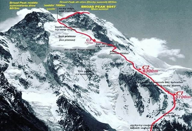
On the Standard Route, the Base Camp is established at 4,900 m (16,076 ft) on the Godwin Austen Glacier to the north-west of the summit.
Camp 15,400 m (17,717 ft)
Camp 1 is established at 5,400 m (17,717 ft) with some fixed rope climbing required to gain the beginning of the ridge.
Camp 2 (6,250 m/ 20, 505 ft)
Camp 2: The route to Camp 2 (6,250 m/ 20, 505 ft) is the steepest section of the whole route, demanding ice and rocky steps to be scaled. The reward is the first spectacular views of K2 and the enormous Baltoro Glacier.
Camp 3-4 7,100 m (23,294 ft) and 7,500 m (24,606 ft)
Camp 3 and 4 are established at 7,100 m (23,294 ft) and 7,500 m (24,606 ft) respectively. Sometimes Camp 4 is not necessary, if the conditions are good enough to make a summit attempt directly from Camp 3.
Summit 8047-M
The route heads passed the summit on the West Ridge before cutting back (at Camp 4) to the south-east to gain the summit.
On the summit you’ll find a ski pole attached with red and purple rope. This was left here by Hans Kammerlander in 1994 after numerous ‘successful’ ascents actually only reached the fore-summit. Make sure you snap a picture of that man-made marker to prove your summit success! Descent follows the same route back down to Base Camp.


