Peak Highlights
Height: 8,126 m (26,660f )
- NP The World’s 9th Highest Mountain Stands 2nd highest of Pakistan .
- Location: Part of the Himalayan Range of Pakistan.
- First Climbed: 1953 by Austrian
- challenging eight-thou sander
- Technical mountains
- HAPs/Sherpa's supported climb.
- Three faces climbing routes Peak
| Range: | Country: | ||
|---|---|---|---|
| Max Altitude: | Duration: | ||
| Best Season: | Walking per day: | ||
| Grade: | Ideal Group Size: | ||
| Hotel Nights: | Camping Nights: |
Book your own customize Expedition 2022-23
| Arrival | Departure | No of Persons | Trip Name | Confirmation Deposit | Status |
|---|---|---|---|---|---|
| 25% | Book Now |
Fix Departure Date And Prices 2024-2025
| Start Date | End Date | Availability | Price | Confirmation Deposit | Group Size | |
|---|---|---|---|---|---|---|
| 1st June 2024 | 15th July 2024 | Available |
$000 €000 |
$30% | 7 to 12 | Book |
INTRODUCTION OF NANGA PARBAT.
Nanga Parbat is the ninth highest mountain in the world and second highest peaks of Pakistan. The Sanskrit word parvata means “mountain rocks” and nanga means “bare”). It is located in Diamir and Astor is a part of Himalayan Range of Gilgit-Baltistan Pakistan.
An immense, dramatic peak rising far above its surrounding terrain, Climb Nanga Parbat also notoriously difficult. It has three vast faces. The Raikot face is dominated by the north and south silver crags and silver plateau. The Diamir face is rocky in the beginning. It converts itself into ice fields around the higher end of the peak. The Rupal face is the highest precipice in the world.
It was first climbed on July 3, 1953 by Austrian climber Hermann Buhl, a member of a German-Austrian team. By the time of this expedition, 31 people had already died trying to make the first ascent. The final push for the summit was dramatic: Buhl continued alone, after his companions had turned back, and spent a night standing up on the descent. Buhl is the only mountaineer to have made the first ascent of an eight-thou sander solo (at least at the summit) and without oxygen. Most trending 8000m Mountaineering in Northern Pakistan.
Climbing Guide To Nanga Parbat;
There are no easy routes up Nanga Parbat. With a significant vertical relief in all directions, you have to be prepared for a very difficult climb, wherever you approach the mountain from. There are three faces of climbing,
DiamirFace , Rupal Face and the Raikot Face.
The Diamir Face routes.
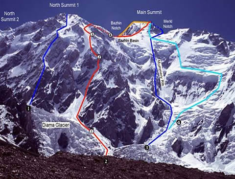
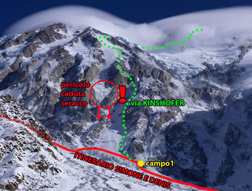
The Standard or Kinshofer route follows the line of the second ascent of the mountain (1962), and heads up the Diamir Face. This route avoids the avalanche danger of the centre of face, where massive hanging glaciers threaten overhead.
Instead, it climbs the buttress to the left of the face to reach the Kinshofericefield. This means the majority of elevation is gained early in the climb, meaning a longer period at high altitude. The Bazhin Gap is then traversed before climbing around the North Shoulder to reach the summit climb.
There are three other routes that have been attempted.
The Messner route was set in 1978 during his solo ascent and takes the right-hand side of the face. While this involves a steadier climb, most of it is over glacial terrain, with a looming avalanche risk a constant threat to the south. This route joins Mummery’s intended route (below) via the Bazhin Basin for the final climb to the summit.
The most recent route was opened in 2009, known as the Austro-Canadian North-west Buttress route. This detours to the east of the Standard route for more than 2,000 m of the climb. It uses a previously unknown couloir, now known as the Göschl Couloir, to access the north-west buttress. The route Mummery took in 1895, known as the Mummery Rib, has never again been attempted as an ascent. This routes heads more or less up the centre of the face. But the terrain of an unpredictable glacier has always proven too difficult to be successful. It was used by Reinhold Messner, however, to descend the mountain following his successful climb of the Rupal Face (see below).
The Raikot Face;
The Raikot Face has two routes: the Buhl route and the Japanese route. The Buhl route was the one opened on the Hermann Buhl’s first ascent of Nanga Parbat. This route begins on the Raikot glacier and climbs towards Raikot Peak (7,070 m/ 23,196ft), east of the true summit. From here it traverses to the north of the peak, gains the ridge-line and passes to the south of the East Peak (7,597 m/ 24,925 ft) through a bottleneck known as the silver saddle. The final section climbs the north ridge to shoulder of the summit, and requires technical climbing of a very high order. It is for this reason, attempting such climbing around and above 8,000 m, that the route is no longer in use. The Japanese route stays much closer to the North and East Peaks, climbing directly up the Raikot Face below the East Peak, traversing to the north ridge, gained near the North Peak. To avoid the technical climb of the Buhl route, the Japanese route descends onto the Diamir Face to reach the summit via the Bahzin Gap (west).
The Rupal Face
On the south-facing Rupal Face, six different routes have been attempted, though two are yet to be successfully completed.
- The Messner route, via the south South-east Spur. First completed in 1970.
- The Schell route, via the upper South-west Ridge. First completed in 1976.
- The South-east Pillar route. First completed in 1982.
- The Direct South-East face route, via the Central Pillar. First completed in 2005.
- The South Face Direct route, as yet unclimbed.
- Another Direct South-east face route, as yet unclimbed.


